The knowledge gap
Despite clear evidence that shipping activity—through vessel collisions, noise pollution, and disturbance—severely impacts marine megafauna like cetaceans, sea turtles, pinnipeds, and seabirds, there was no comprehensive global map to guide conservation efforts. We lacked the vital knowledge to distinguish between undisturbed biodiversity refuges and high-risk conflict zones at a planetary scale.
Main approach
We conducted a global assessment by overlaying two critical layers: a composite measure of species richness for the four vulnerable faunal groups and vessel density derived from Automatic Identification System (AIS) data. By classifying both metrics into terciles (low, medium, high), we were able to define two new conservation categories:
Priority Preservation Areas (PPAs): Regions of high species richness overlapping with low or minimal shipping activity (biodiversity refuges).
Priority Mitigation Areas (PMAs): Regions of high species richness overlapping with high shipping density (high-risk conflict zones)
Technological challenge - how we tackle the study
The core challenge was translating vast, continuous streams of global maritime traffic (AIS data) and highly dynamic species distribution models (AquaMaps and BirdLife) into a single, actionable risk assessment framework. We used a bivariate mapping approach in R to synthesize these complex datasets, enabling us to quantify the interplay between biodiversity value and potential impact risk across every marine grid cell, making the findings globally consistent and scalable.
Main finding
Our maps reveal that biodiversity is concentrated in two major zones. PPAs—our ocean’s last large, undisturbed refuges—are predominantly found in the remote, high southern latitudes, near Antarctica. Conversely, PMAs are clustered along coastlines and in critical trans-oceanic passages, especially in the mid-Pacific, southern Indian Ocean, and South Atlantic.
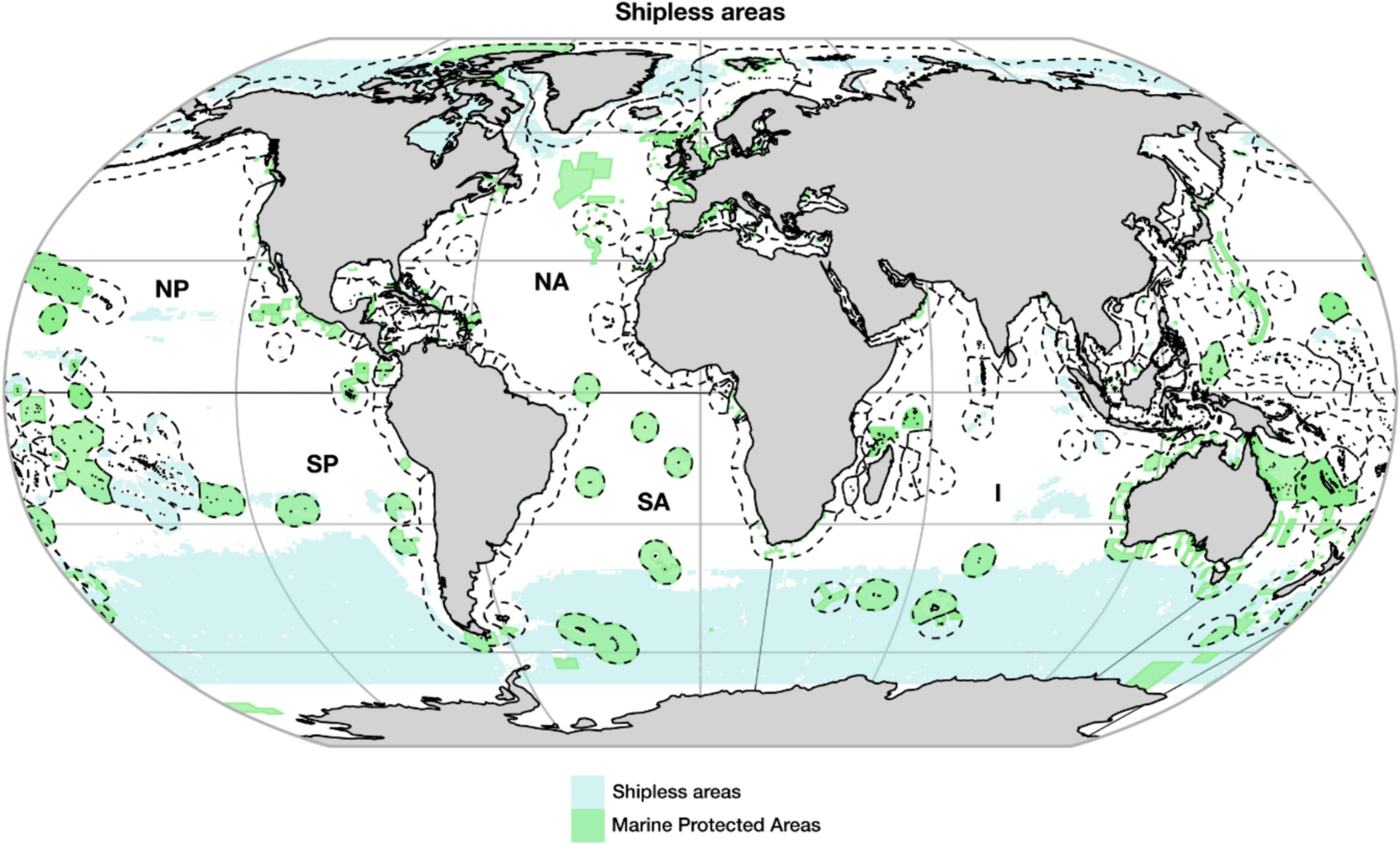
Fig. Distribution of shipless areas (blue), representing regions with minimal or negligible vessel activity. Marine Protected Areas (>100,000 ha) are overlaid in green, while Exclusive Economic Zone boundaries are marked with dotted lines.
Crucially, we found that existing Marine Protected Areas (MPAs) are currently falling short: they cover only 15.2% of PPAs and 16.2% of PMAs, leaving vast priority areas unprotected or unmanaged.
Main implications for conservation and management of biodiversity
These findings provide a clear roadmap for achieving global marine conservation goals, including the UN 2030 Agenda for Sustainable Development and the 30 x 30 target. We need a dual-strategy approach to marine spatial planning:
Preserve: Immediately designate the identified PPAs as new MPAs or equivalent conservation measures to safeguard these essential, shipless biodiversity refuges before future traffic routes encroach.
Mitigate: Implement targeted shipping management strategies in PMAs, such as mandatory vessel speed reductions to minimize lethal collisions and noise pollution, and dynamic traffic rerouting to avoid seasonal biodiversity hotspots.
Govern: Use this framework to inform international policies on the High Seas, helping countries and organizations balance vital maritime trade with the urgent need to protect vulnerable marine ecosystems.